the video describes the process of producing silk.
the video describes the process of producing silk.
BEIJING, June 6 (Xinhua) — The “Silk Road Spirit” could become a guiding principle in solving complex regional and international issues.
Peace and cooperation, openness and inclusiveness, mutual learning and mutual benefit, form the core values of the Silk Road Spirit, as proposed by Chinese President Xi Jinping at the sixth Ministerial Conference of the China-Arab States Cooperation Forum (CASCF).
In the ancient time, it was through the Silk Road that the Chinese inventions of paper-making, gun powder, movable type printing and compass were spread to Europe via the Arab region and that the Arab astronomy, calendar and medicine were introduced to China.
In the present time, China, located in the East Asia, and the Arab countries, which are mainly located in the West Asia and North Africa, are carrying forward the Silk Road Spirit and deepening cooperation in political and economic fields.
China and Arab countries will also jointly build the Silk Road economic belt and 21st century maritime Silk Road. The two concepts were put forward by Xi during two separate visits to Central Asia and Southeast Asia in 2013.
When the Cold War ended, the international security situation remained complex. Both East and West Asia are facing up to traditional and non-traditional challenges and threats. To make matters worse, a certain individual country persistently promotes its own value and political systems and “zero-sum” mentality, complicating the regional situation.
To be different, the Silk Road Spirit means peace and win-win cooperation. When addressing the opening ceremony of the sixth Ministerial Conference of the CASCF, Xi said “We want to achieve development for ourselves and we want to enable others to grow as well.”
Xi also pledged to work with Arab states to encourage dialogue as a way to find the greatest common denominator on issues of concern to all parties, and provide more public goods for the proper settlement of regional hotspot issues.
It’s obvious that China hopes the “win-win cooperation” principle could prevail over “zero-sum” mentality and become an important principle for handling state-to-state relations.
The Chinese president have made many diplomatic proposals with the core spirit of peace and cooperation. Apart from the Spirit of Silk Road, Xi called for a common, comprehensive, cooperative and sustainable security strategy for Asia, when he delivered a keynote speech at the fourth summit of the Conference on Interaction and Confidence Building Measures in Asia (CICA) in Shanghai in May.
Perhaps it will take some time for the world to accept and put more trust in China’s standpoints and hopefully, the cooperation between China and Arab countries could be a good example and solid evidence for China’s win-win cooperation resolve.

Located to the right of the visitors’ entrance to the Grand Palace, the Queen Sirikit Museum of Textiles(QSMT) collects, displays, preserves, and serves as a centre for textiles from East, South, and Southeast Asia with an emphasis on Thailand and its royal court. The QSMT embodies Her Majesty’s efforts to preserve Thailand’s textile arts for future generations. It also highlights the life and activities of Queen Sirikit and her amazing efforts to support her people.
The 1st floor of the QSMT sets up a cute activity hall, which include silk-related knowledge display and visitor interaction. There are tools exhibited to raise silkworms and to weave silk products, dyed silk threads in natural dyes like mangosteen shell, colorful beetle wings to decorate silk garments, etc. Visitors could design their own textile by stamping different textures on an empty post card – stamps with most popular-seen Thai textures are available without charge. It’s also encouraged to ask a staff to help you write down your name in Thai on your post card.

All exhibitions are on the 2nd floor of the QSMT. It displays the origin and history of Thai Style suits designed and popularized by the Queen Sirikit, types of Thai Suits and dresses, dresses worn by the Queen on her foreign travels, as well as the process from raising silkworms to making silk garments, and fine art of decoration to garments. The QSMT also introduces a caring project initiated by the Queen Sirikit, the SUPPORT Foundation. Women in rural areas are encouraged to weave silk products and sell to the SUPPORT Foundation as a career as well as to raise family. The pictures and video clips reveal the caring of Her Majesty to her people and the respect and love from Thai people to their Queen.

After the tour of exhibitions, visitors can purchase exquisite silk products and souvenirs in Thai style at the Museum Shop before they leave.
The classical research about the origin of Chess concentrated on investigating written and archaeological evidence resulting in opinions about Indian/Persian 1 or Chinese origin of the game. The available evidence was, however, not sufficient for a convincing theory. So the question about the origin of Chess still has to be considered open. Some speculations assumed military, mathematical, or divinification models as the basis for the game. Most scholars of Chess history do, however, agree that the relationships to these models showed after Chess already existed. Another idea, which was part of some theories, was the assumption that Chess, with all its present complexity, was invented by a single person. But this is extremely unlikely.
A significant step towards the better understanding was the founding of the Initiative Group K鰊igstein (IGK2) in 1991 and its seminars, in which the present Chess historians can present their research and opinions. Its member Gerhard Josten looked for evidence in the structure of Chess. He came up with three basic unique elements:the king, the pawns, and the officers (counters, pieces). His theory is that these elements stem from different sources and are combined into present day Chess. This was supposed to be done by either Silk Road merchants, who were waiting for better weather conditions in one of the major trading places like Kashgar in today’s Southwest China, or by game enthusiasts in the Kushan Empire. The Kushans had some experience with merging elements from different cultures. Josten suggests that the king and its behavior is taken from the ancient Chinese game Go, the pawns come from Indian racing games and the officers are taken from divinification or astrological methods. I have added an alternative for the astrological roots of the officer-moves with the possibility that their moves are based on the images occurring within the game of Tic-Tac-Toe.
No matter which theory is valid, the importance of the Silk Road for spreading the game is undisputable. Forerunners and the Chinese Variation Board games are very ancient and can be traced back at least 4, 500 years to the first city of Ur and Egyptian paintings. In the 19th century AD Stewart Culin created the theory that all board games had magical or religious origin. This is not evident, for instance, in the three-dimensional Tic-Tac-Toe (Mill), for which a board was engraved by Roman soldiers on the cobble streets of Old-Jerusalem.
The Egyptian game Senet was clearly a religious game. It was a racing game played on a 10×3 board. There is also a version with 8 linear squares followed by 4×3, the “twenty-game”. The exact rules of either are not known, but boards have been found together with half-flat sticks, the forerunners of dice. The names or meanings of the squares had to do with the stations of the way to the empire of the dead. There are numerous references to Senet in inscriptions and papyrus scrolls. The use of Senet as an Egyptian glyph gives an indication of its importance. According to the Nordic poem, The Edda, the Germanic gods spent their free time in their residence Asgard playing board games, but The Edda was not written down until the twelfth century AD.
A possible forerunner of Chess is an Indian game, known as Ashtapada, which means in Sanskrit a square board of 64 squares, 8 rows of 8 squares. It was played with dice and pieces, a race game possibly going back to the fifth century BC. Chinese records mention its introduction from India to China as early as 220 BC to 65 AD, roughly during the early Han Dynasty.
The likelihood of a race-game being a forerunner of Chess is preserved in the promotion of a pawn to a piece when reaching the 8th row. Hinduism prohibits gambling. The revival of Hinduism during the Gupta Dynasty led to an enforcement of this antigambling policy in the 6th century AD. This is used as an argument by some scholars for supporting the idea of an Indian origin of Chess. It is stated that the suppression of dice forced the transformation of a race game into a strategic game. When I discussed this with some Indian historians during a visit to India, I got clarification that the gambling inhibition was local and did not apply to total India.
Chinese Chess today is played on a board with 9×8 squares or 10×9 edges. The pieces, inscribed draughtsmen, are placed on the edges and not on the squares of the 9×8 field. The use of inscribed draughtsmen instead of stand-up figures means an additional level of abstraction and would therefore speak against an origin in China. However, sources suggest that originally Chinese Chess was also played with standing figures. In the middle of the 10-row field is a “river”, which was added later, meaning originally that the board was 9×9, considering the edges, or 8×8 considering the squares. The number nine has a special importance in China. Ancient Chinese regarded odd numbers as being masculine and even numbers as being feminine. Nine, the largest single-digit, odd number, was taken to mean the ultimate masculine, and was symbolic for the supreme sovereignty of the emperor. It was sometimes combined with the number five to represent imperial majesty. Tiananmen Hall is 9 bays wide and 5 bays deep. The combination 9×5 also appears on the two halves of the Chinese chessboard (after inclusion of the river). The transfer to a 9×9 board from an 8×8 one, based on the imperial importance of the number 9 seems more likely to have happened than the other way around.
The oldest clearly recognizable Chess pieces have been excavated in ancient Afrasiab, today’s Samarkand, in Uzbekistan. These are seven ivory pieces from 762, with some of them possibly older, meaning that they stem from the 6th to 8th century AD. It is not clear whether one of the pieces can be identified as a Queen. Otherwise, the occurrence of the 6 different pieces within a sample of seven out of the total 32 pieces is statistically surprising. The pieces today are kept in a downtown museum in Samarkand.
Some other old pieces, possibly Chess pieces, are the occasionally named Chess pieces of an elephant and a zebu bull kept in Tashkent. They were excavated in Dalverzin-Tepe, an ancient citadel of the Kushan Empire now in Southern Uzbekistan, and stem from the 2nd century. The Russian Chess history expert Linder feels that they are not Chess pieces, but belonged to a forerunner of Chess [Linder 1994]. They could mean an earlier than previously assumed existence of Chess. Second, there is a piece in the Metropolitan Museum in New York from the 6th or 7th century, bought in Baghdad around 1930, representing an elephant out of dolomite stone of 2-7/8 inch height [Gunter 1991]. An ivory piece, probably a Chess piece from the 6th century, has been excavated recently at a Byzantine palace in the ancient city of Butrint in Albania. This modifies the theory that Chess was moved to the West by the Arabs in favor of Christian/Byzantine involvement.
The oldest known Chess books or parts thereof are in Arabic, written about 850 AD. Before that, there are only incidental possible references to the existence of the game in Arabic, Persian, Sanskrit, or Chinese literature, but there is no complete description of the game, nor an indication that rules had stabilized. The earliest mentions stem from around 600 AD. Chess or Chaturanga 3 have not been mentioned in an otherwise very complete travel report by the Chinese Buddhist monk Fa Xian, who traveled through India at the beginning of the 5th century AD. The total number of Persian references to Chess from around 600 is two out of a total of five works of middle-Persian secular literature which are known to have survived from that period. Very little is known about Chess in India for about half a millennium after that. It is not clear whether the Chess mentioned by the Persian sources was a game for two or for four players, whether it was played with dice, and what moves were allowed. The conclusion by Murray [Murray 1913] and Eales [Eales 1985] is that before the 7th century, the existence of Chess in any land is not demonstrable. Eales mentions that the compiler of a 12th century Chess manuscript wrote “It is universally acknowledged that three things were produced from India:the game, the book Kalila wa Dimna (a book of literary fables) and the decimal numbers (including the Zero).”
Ann C. Gunter [Gunter 1991] reports about one of the surviving texts in Middle Persian, The Explanation of Chess and Invention of Backgammon (Wizarishn i catrang ud nihishn i new-ardashir). In a said competition between the great Sassanian ruler Khusraw I, who ruled from 531 until 579, and the Indian King Dewisharm, Dewisharm sent a Chess game to Khusraw requesting that Khusraw’s wise men explain the rationale of this game. The wise man Wuzurg-Mihr explained the rationale of the game and then proceeded to a challenge of his own to the Indian ruler. This supposedly was the invention of Backgammon (called nard in nard in nard the literature), and the invention of present day dice (the numbers of which correspond to cosmological principles of the then common Persian religion, Zoroastrianism). Dice were, however, already known by the ancient Egyptians and certainly not invented as late as Khusraw I’s time. It has not been possible to locate Dewisharm, and to find out which of the kingdoms that existed after the fall of the Gupta Dynasty that he ruled.
Sloan [Sloan 1985]bases his theory about Chinese Chess origin on two Chinese poems, one stemming from the 2nd century BC. Since Chess is often wrongly confused with the far older Go, this could also be the case here (or a mixup with another board game).
The Sinologist Joseph Needham and Pavle Bidev, both part of the Initiative Group K鰊igstein, have, based on the theory about religious roots for all board games, suggested that the historical Chess of 7th century India was directly descended from a divinatory game (or ritual)in China. Bidev suggests that Chess has its roots in the cult of the Chinese god Thai Yi. Needham has shown that there are references to an “image-game” (hsiang chhi is elephant-game or image-game) in works of the 6th century, devised by the Emperor Wu Ti (561578) from the Northern Chou-Dynasty. The emperor even gave lectures on the game to his staff. It was, however, not Chess since according to early sources it had as its pieces the sun, the moon, the stars, and the constellations, meaning that it was in all likelihood a complex astrological ritual. Interesting in Chinese Chess is the 3×3 fortress, an exact image of Tic-Tac-Toe.
There is an analogy between the Indian army and the Chess army. Chinese armies did not have elephants, or only very occasionally had a limited number in the southwestern part of the China.
The earliest Chess terms appear in Sanskrit, the Persian and Arab versions are very similar. Whyld points out the fact on the IGK website (http://www.netcologne.de) that the first Chess terms mentioned appearing in Sanskrit is not convincing. He also mentions the fact that in the story of Chess moving from India to Persia it is said to come from Hind, a name which was not used for India until after the 11th century AD.
Davidson [Davidson 1949] studied the “Geography of Chess”. Starting with India he finds four major radiations:A northeast radiation into China, between 800 and 1000 AD along the Silk Road;a southeast radiation into Burma and Indo-China, between 800 and 1100 AD;a westward radiation into Persia and the Arab countries, between 600 and 800 AD, reaching Spain before the 1008 battlefield will of the Count of Uregel, which directed the inheritance of his Chess-pieces;and a northward radiation into Siberia, between 1400 and 1500 AD.
Gerhard Josten from the IGK bases his “merger theory” on three elements in the structure of Chess. The element of hunt games is represented by the king, the element of divination counters for the moves by the officers and the element of race games by the pawns.
The imprisonment of the king occurs in a similar way in the Chinese territorial game Go, called Weiqi 4 in China, which means this element likely comes from China. Go is played on a 19×19 board by placing alternatively black and white pieces on the board. Horizontal and vertical connections of pieces of the same color form chains. The number of empty fields neighboring any members of a chain horizontally or vertically give the degree of freedom of the chain. A chain, including one consisting of a single piece, without any degree of freedom is taken prisoner. The situation of one piece taken prisoner could be the one which was applied to a mated king in Chess.
Josten believes that the officers have their origin in old divination techniques, but in difference to other authors he believes that the divination techniques apply only to the officers and not to the complete game of Chess. Based on the fact that the geometry of the Babylonian astrolabe allows all of the important types of moves of the Chess officers and the external kinship of the astrolabe to the Byzantine Chess board, Josten states that the Babylonian astrolabe is an adequate ideal for these pieces. Supporting the astronomical/astrological connection is the 19th century theory that all board games have religious roots. Chess has been from the beginning a game for intellectuals and astrologists were considered in ancient times part of the intellectual elite. In antiquity, the stars were looked at as either images of gods or subjects with which the gods chased around. This is the justification for astrology and possibly for an early use of the game of Chess to obtain oracles. The astrolabe constitutes an analog computation device 5, consisting of various rings movable against each other. The user found the altitude of the sun or stars by means of a graduated circle on one side of the device and then turned to the other side to perform his calculations on the movable star map, a two-dimensional representation of the three-dimensional heavens. The straight line moves occur in these operations, the knight move is a combination of both. These methods are also indicated in ancient astroglyphs from Chaldaean times.
As an alternative possibility to the divinification I offer, the game of Tic-Tac-Toe could be viewed as providing the roots for the moves of the counters. Tic-Tac-Toe is played by 2 players, e. g. Black and White, with a set of pieces of equal value each, on a 3×3 board. The players move alternatively with the goal to get three of the own pieces in one horizontal, vertical or diagonal row. In the following diagram, that goal is achieved by occupying the points 1, 2, 3, or the parallels;the points 1, 4, 7, or the parallels;or the diagonals 1, 5, 9, or 3, 5, 7:
| 1 | 2 | 3 |
| 4 | 5 | 6 |
| 7 | 8 | 9 |
Tic-Tac-Toe was played at least 3000 years ago. It is also called “Three Men’ss Morris”, where “morris” is a corruption of merels, the Latin word for counters [Pritchard 1994]. From a game-theoretic point of view, it is always a draw and is trivial. A more challenging extension was played extensively 6. The placing of the following piece of the same color (2 moves ahead) is either vertical, horizontal, diagonal or in diagram (1)the point 8 following the point 1, or equivalent sequences this is similar to a knight’s move in Chess. Thus all move sequences of the pieces in Chess are represented.
The pawns and their idea almost certainly come from India. Most of the ancient board games seem to have been racing games played with dice or its forerunner, sticks with one flat side, which were thrown and the number being determined by the number of resulting flat sides being up or down.
Ashtapada is an ancient Hindu race game played with dice on an 8×8 board, which later might have become the Chess-board. The method of play for Ashtapada has been forgotten. It seems logical that there has to be an incentive for succeeding in a race, which is given by the conversion of a pawn into an officer, when the pawn reaches the last row 7. To change a gambling game into a strategic race game requires some strategic possibilities to block or speed up the race, such as opposite pawns and the possibility to take an opposite piece by a diagonal move.
A challenge for this theory is to explain the use today, and in the total history of Chess, military names for the officers with no previous names for these pieces being known. Also in the early Arab sources the king is not imprisoned but killed.
As far as the area of origin is concerned, Josten points to the Central Asian Kushan Empire, a culture that had intensive contact with the Near East, India, and China. It would have combined various elements from games from these regions in one game. The Kushans, called “the forgotten Kushans” by some scholars, ruled from about 50 BC until about 200 AD a big empire, which included a substantial part of India, and included the excavation place where the above mentioned 2nd century AD “Chess-pieces” were found. The Kushans, having become affluent by trading on the Silk Road, were privy to cultural mergers as shown by their contemporaneous tolerance of Buddhism and Zoroastrianism, as well as their gold coins displaying Greek, Roman, Iranian, Hindu and Buddhist deities.
Josten’s hypothesis about the Kushan origin from the days of the Kushan Empire would imply a lack of reports about Chess for about half a millennium before 600 AD, which might be explained as having been a maturing period. The two pieces from Dalverzin-Tepe could support the theory.
Another thought would be that Chess emerged on the Silk Road, when merchants were idly waiting for better weather conditions for travel, and playing board games. A key place of this type was Kashgar in today’s far western China, which also belonged for a time to the Kushan Empire.
There are a number of books on Chess history, in particular the scholarly studies written by H. J. R. Murray [Murray 1913] and Richard Eales [Eales 1985]. The German book by H. F. Maßmann [Maßmann 1839] dismisses older legends about the origin of Chess, like the one that Palamedes of Euboa invented it during the 10-year siege of Troy in order to help avoid boredom among the Greek soldiers. Maßmann is of the firm opinion that Chess was invented in India and came from there via Persia and the Arabs to the West. The beginning of historical research about the origin of Chess is a 1694 publication by Thomas Hyde, De Ludis Orientalibus.
Hyde states the facts implicit in older Arab sources, leading to his conclusion that Chess originated in India and then traveled by way of Persia and the Arab world to western Europe and on the Silk Road to the East. The myths and legends before Hyde are all not historical, but all of them, except those of obvious later invention, point to Persia or India as the country of origin.
Li [Li 1998] refers to a publication by Irwin, read in 1793 in Dublin [Irwin, An Account of the Game of Chess, as Played by the Chinese, Transactions of the Royal Irish Academy (Dublin 1793), pg. 53-63]. According to this paper, Chess was invented by the Chinese General Han Xin to mentally occupy his troops during a long winter reciprocal surveillance in 204-203 BC. Li describes in detail how he believes Han Xin decided on the layout and moves, which eventually led to the Chinese form of chess. Han Xin died in 196 BC. Li mentions that there are citations in Irwin’s paper, but he does not give any. I agree with other authors that a paper written 2, 000 years after the fact does not constitute proof.
Josten points to the history of the British colonialism in India. The majority of India was under the control of the East India Company in the first half of the 19th century. As a result of revolts in 1857 the Company was dissolved and India was placed under the direct control of the British Crown. In 1909 Britain granted India some self-government. Josten suggests that the researchers Thomas Hyde and H. J. R. Murray, who were active during the 19th and early 20th century found willing ears with their claim of an Indian origin of Chess. This of course neglects the contributions of the early German researchers who reached similar conclusions to the British ones.
Unfortunately, written references to Chess or its development have not been found yet from before the two Persian records of about 600 AD. It is very unlikely that Chess, almost as it is played today, suddenly came into existence, invented by one person. The idea of it being a combination of elements from other board-games has merit. Since almost all known board games have religious backgrounds the astrological component is entirely possible, even though I prefer the version that all elements come from other games, e. g. Tic-Tac-Toe, as the basis for the counters. Kushan as the area of origin is highly possible, especially because of the 2 excavated debated pieces from the second century AD, which were found in the area of the Kushan Empire.
The books are by no means closed. In my opinion, the Chinese origin is the least likely one from the ones discussed. Josten’s hypothesis is very intriguing but still needs some more work. The theory about India being the original country seems to hold together but will probably have to give in to another theory because of the lack of reports about follow-up within India during the next 500 years after 600 AD.
China National Silk Museum (CNSM) – Hangzhou

Near the West Lake in Hangzhou, CNSM is the first national silk museumin China and the largest silk museum in the world,covering an area of 50,000 m2 and a building area of 8,000 m2.
It was opened in February 1992, and welcomes visitors without charge since 2004. Exhibiting China’s 5,000-year silk culture and its developmental achievements, CNSM’s main goal is to research and conserve Chinese textile relics.
Its permanent displays include “The Story of Chinese Silk”, “Sericulture and Silk Craftsmanship in China”, “Textile Conservation Gallery” and “Xinyou Archive Center”.
There are also silk boutiques and teahouses opened for entertainment.
Visitors could experience every detail about silk from 9:00 – 17:00 everyday (12:00 – 17:00 on Monday except holidays),with no entrance after 16:45.

l Suzhou Silk Museum (SZSM) – Suzhou
www.szsilkmuseum.com (Chinese)

SZSM was first established in October 1989, and the newly designed SZSM was opened in September 1991 and it becomes the first specialized museum of silk in China.
Located in the scenic spot of North Temple Pagoda, SZSM covers an area of 9,460 m2 and a building area of 5,325 m2. The theme and the architecture design of SZSM are exactly the Silk Road. Silkworm, Mulberry, Silk thread and Silk are the four Chinese characters which concisely summarize all contents to be seen in the museum.
In the Modern Hall, visitors could also see virtuosity of Suzhou silk,information about silk masters and celebrities, and silk evolution in Suzhou, etc.In a silk shop located in an ancient-style street, visitors can exchange for specially-made archaistic coins to purchase diverse silk products.
SZSM welcomes visitors without charge from 9:00 to 16:30 daily.
Three kings of Assyria and King Solomon of ancient Israel placed orders with the traders of Saba, and none were disappointed. Delivery by camel and later by ship continued, despite political change in both the southwestern Arabian Peninsula and in the northern areas of the coastal east Mediterranean lands and inland Mesopotamia, modern Iraq.
As one aspect of the ancient Silk Route involved in the movement of Far Eastern, Indian and Indian Ocean island products, the traders of Sheba were secretive about the origins of the desired items. Gold, frankincense, myrrh and a vast variety of medicinal herbs from the Indian subcontinent increased in price as they passed through controlled warehouses and checkpoints moving to their destinations in the north. However, many of the items came from further east than their purchasers realized. The fabled land of great wealth, Saba, responded to a market economy and was often a middle man in the process.
I will discuss the early inland cities of Marib, the Sabaean capital, Tumna, the capital of Qataban, and Shabwa in the Hadramawt; all of these were sited around the edge of the Ramlat Sabatayn desert, and were part of a chain of small kingdom cities in what is modern day Yemen. We will also visit the site of Qana, a port on the Indian Ocean whence the Romans later received their myrrh and frankincense.
The Silk Road is a 19th century name created by a visionary European scholar who labeled, and thus created an image for an ancient trading system of the first millennium AD. He certainly would be hired by any top level advertising agency of the 21st century. From Xian in China, to the eastern Mediterranean coast by a single route is to understate the case and is too narrow a definition. This name described a vast trading complex which was more intricate both in the number of commodities it carried and the routes it followed than is implied in the name. Today’s Superhighway of the internet would be a closer parallel.
Where does the modern Republic of Yemen, and my title “Sheba@SabaTrading. com” fit into the ancient map of a Silk Superhighway? The southwest Arabian Peninsula was a transshipment point from the early first millennium BC for items from India and Ceylon via the long, north-south camel caravan route traversing the Arabian Peninsula. Saba, as the main federation was called, sent to the Mediterranean kingdoms and inland Mesopotamian cities of the royal courts of Assyria and Babylon the fragrances they used to burn for their gods; these included frankincense and myrrh. Indigodyed cloth, pepper, cardamon, and precious stones all passed through the fabled land.
Yemen is not attested as a country name until the beginning of the first century AD; it means simply the south or the right hand side. The almost unbelievable longevity, and affection of the people of the southwest of the Arabian Peninsula for their country and its past is so strong that any number of companies reflect the ancient name in their modern trading name. There are Saba or Sheba gas stations, hotels, barber shops, juice stands, and groceries, and in all of them the name embodies a history of trading which goes back to the early first millennium BC. No anonymity here, no abstract Silk Route which names neither the beginning nor the end, nor the rulers of the countries involved. We hear from the angry vassal of the King of Assyria, situated at a trading post on the middle Euphrates, of the aggressive tactics and tax avoiding habits of the traders of Sheba as early as 850 BC. The caravan was skirting around the town to avoid paying the tax on goods they were taking back to Yemen.
However, until the sea routes through the Red Sea and a fast open sea passage to India using the monsoon, superceded the long overland camel caravans it is probably fair to say that any Chinese-Yemen connections were nebulous. The critical shift took place in the first century BC. That silk was esteemed, we know from a retrospective description by the 10th century Arab historian al-Hamdani. Where he describes the windows of Ghumdan, the last Sabaean royal palace in Sanaa thus;” of teak wood hung with silk curtains, ” this description provides a clear demonstration of both an eastern connection for trade, and a pleasure in luxurious and prestigious items.
To understand the distribution pattern of the traded items, through and out of Yemen, it is necessary to understand both the geography of the country, and its political structure throughout the first millennium BC and for the early part of the first millennium AD. One must remember that many traded goods were thought by Mediterranean purchasers to have originated in Yemen; this was an error of omission since many came originally from India and Ceylon, or from the African coast.
The physical map of Yemen shows the uplifted north-south range of mountains; these form a barrier between the inland areas and the coastal strip on the Red Sea. The narrow Tihama is home to fisher people. Today all memories of its former coffee glory, in the Rasulid period, at the small port of Mokha are forgotten. A mocha at Starbucks is more alive. This was not always the case and very early occupation of the land along the coast dates from between 8, 000 BC and 6, 000 BC, when fish eating Neolithic communities subsisted on the wealth of natural marine resources and flourished. This culture spread from the north at Sihi in modern Saudi Arabia all the way around the Bab al Mandeb to Aden, developing into a Bronze Age coastal culture. Recent research suggests that in the eighth century BC a connection was established across the Red Sea by the Sabaeans, who set up a colony settlement in Ethiopia at Axum. Our early traders did not sleep. The Red Sea was difficult to navigate for early vessels and a strong wind pattern can only be used to advantage up until the 20 degrees north; beyond this latitude, sailing can only be accomplished in the winter season when a southerly wind aids shipping and the strong north wind abates. The ports of Qusair and Jedda reflect this need to have an overland option, and a land transshipment port at this point of the Red Sea; it was this physical constraint which allowed the Nabateans to gain such power on the Arabian side, as they controlled the northern end of the trade route in the early first millennium AD.

The uplifted mountains of the coastal range reach 9, 000 feet and it was on the upland plateaus created by these mountains that the early Bronze Age farming communities settled and created their wealth during the second millennium BC. Upon this base, later, technologically superior kingdoms developed to the west on the edges of the Ramlat Sabat’ayn, which desert rarely reaches 900 feet. The interaction between the resource-rich higher settlements and the resource-poor, lower desiccating desertedge settlements catalyzed development in the lower areas whose income ultimately derived from the control and exploitation of trade caravans. There the sub-desert climate is associated with steppe vegetation; it was control and advanced water technology that enabled the cities to feed large populations and thus survive. Research in Yemen has lagged far behind that of other near eastern countries and the mountain settlements have only been documented in the last ten years. Early excavators were surveying in the wrong areas, sure that earlier occupation should be associated with deeper levels of the cities associated with the mid-first millennium incense route. Certainly, deep sediment deposits were documented at Timna and at Marib, and the growth of these cities was not precipitous.
The origin of our caravans transporting their wealth to the Mediterranean was coincidental with the domestication of the camel as a beast of burden. A short east-west copper transportation route across Sinai was the first experimental route in 1500 BC. Only the camel ¡ªin Arabia the one humped dromedary ¡ªcould sustain long dry spells between the wells at the oases. We find, therefore, that the route from the source of the frankincense and myrrh to the destination at Gaza on the Mediterranean is predetermined by spaced watering wells for the camels. These had to be associated with strongly guarded and armed storage areas controlled at each stop by powerful leaders. Shifts in power were constant and the route moved accordingly.
To understand the role Yemen was destined to play in the Silk Route it is necessary to understand its role in both space and time. The relationship of Iran, India, and Ceylon trading east to China and also west to Yemen is critical. They were early pivot points. In the first millennium BC, Yemen is trading alone, carrying the products from these three by overland camel trade to Gaza. The shift to maritime transportation was essentially the point when a more fluid China to Gaza operation began, and the long Yemeni coastline profited the homeland in the second phase of the route in the first millennium AD.
To follow the overland route, we must start at the area of its greatest resource wealth. The southeastern region of Yemen in modern Shihr and Hadramawt was the prime growing area for frankincense resin producing trees. While it appears that the trees were farmed in earlier times the range of suitable habitat is primarily but by no means only in this area. Earlier explorers report frankincense trees in all of the main river valleys as far north as the Asir highlands of modern Saudi Arabia. The gum was gathered in spring and autumn when the tree trunks were tapped. The resin was gathered and transported to the first station at Shabwa. This is located inland, on the southwestern edge of the desert. The Royal Palace of the king of Hadramawt was excavated by the French, and an associated deep sounding made. Today, it is a ruin and only occasional tourists make a visit. We have no documentation from this site of the trade policies. A sealing and seal from the deep sounding date to the late first millennium BC. The documentation of commodities in this case appears to have been made on parchment, with the document rolled and held by a string, the knot sealed and stamped. This is the only example I know of this technique in Yemen. Close to Shabwa is an old salt mine, called Ayadime, and this must certainly have been a strategic resource in the ancient period for the preservation of fish. Today, chunks of salty dried shark are carried north and held in high esteem as an aphrodisiac. The salt is excellent and still used today.
The next stop is Tumna, the capital city of ancient Qataban. Excavated from this site is a market decree dating to the fifth century BC. This text was published by Beeston, and it can be compared to the rules of the Sanaa Suq today. The text was inscribed on a stone column, and was set up in the middle of a central clearing for all to see. Those who could trade were named, and taxation and payment rules rigorously stipulated. A rasifum building, possibly a raised platform associated with a temple, was probably the area of the ancient market.
This building and a temple was excavated in the fifties by W. F. Albright, again by the French in the nineties, and today by the Italians. The nearby necropolis of Tumna has been a source of illegal antiquities. Many of the carved alabaster statues of bulls ?heads and memorial plaques originated there. The necropolis is unusual, in that the design of the tombs, which are ossuaries with narrow central passages, is not duplicated elsewhere in Yemen. A continual tension between the small kingdoms existed, and in the fourth century BC the Qatabanians succumbed to become part of the Sabaean Federation.
The route from Tumna to Marib, the capital of the Sabaean Federation, lies in a northwesterly direction. The Nagd Marqad path lies around the edge of the desert, a longer, flatter route. There seem to have been political reasons at certain periods to use the steeper and possibly shorter Mablaqah Pass. This pass is a dizzying track up and over a low mountain which leads into the Wadi Harib. The modern town of Henu esZureir, the location of ancient Haribat, was another watering point. A memorial inscription carved at the top of the pass was sadly destroyed by road improvements in the last ten years;it was dynamited and lost after 2,000 years. The fortified ancient town of Haribat was built with the outer house walls as part of the city defensive wall system.
Marib, ancient Mariaba, and its fabled gardens and dam is so large that even today it is difficult to read the ancient topography. The medieval city sits on top of the ancient palace and scattered throughout the valley are ancient temples and mounds. The dam, which tamed the Wadi Dhana, is a sample of the fine stone working techniques and engineering sophistication available to the inhabitants. Today reevaluation of the Mahram Bilquis is ongoing by the American Foundation for the Study of Man, while the German Archaeological Institute teams are working in the cemetery and also on the citadel. The Baran temple, recently restored by the German Institute, was reopened for visitors after a 1, 500 year pause.
From Marib, the caravans wend their way north to Qarnu and on to Najran, now in Saudi Arabia, but Yemeni until quite recently. A border delineation between the two countries was signed in 2000 AD. It is still a further 1, 200 miles to Gaza, having already traversed 430 miles from Shabwa to Najran. Today, desert dwelling bedu drive around in Toyotas and know every outcrop of rock;the topography is dangerous and unforgiving, and one cannot move without a guide. The VHF radio, Toyota, and satellite dish reign supreme there today. They are in touch with the world.
By the end of the first millennium BC, a significant shift in transportation methods led to the beginning of a slow demise of these desert kingdoms. The discovery by Greek sailors that they could sail directly to India on the monsoon and transship through Qana, via Aden and the Red Sea to and from Gaza, created a new power base and a shift in trading practices.
Qana was excavated by a Russian team from the Oriental Institute of Moscow over a period of eighteen years. The elite houses, temples, warehouses, and burials portray a busy port. Large, 15-inch round, cakes of frankincense were excavated in the storage areas and from one of the houses a woman’s hoard of jewelry and bottles demonstrate how a lady of means lived in the first century AD, in a remote outpost.
From Qana the ships sailed to Aden, known to the classical world as Eudymon Arabia, where the safe deep water harbor a part of the ancient volcano was nestled next to Sirah Island. In the area close to the ancient port in modern Crater called Aden by the locals the old, original settlement was, and remains today, inside the volcano’s caldera. Here, I was fortunate enough to excavate a well as a rescue archaeology exercise, before an apartment house was built over it, sealing it forever. It was in the Haflah al Qadi area, on al-Mari Street where three ancient wells are documented.
The Silk Road did indeed pass through Aden, and below the Rasulid level there were discarded Chinese ceramics. These have been discussed with Li He of the Asian Art Museum;noteworthy were a blue cup from Fujian, celadon ware, and early 11th century AD grey-white, fine-paste ware pieces. While the Portuguese forts further along the coast contained 17th and 18th century Chinese porcelains, the well held earlier samples representing continued contact with the Far East. Yemen was without question a part of the Silk Road.
The cheongsam is a female dress with distinctive Chinese features and enjoys a growing popularity in the international world of high fashion.
The name “cheongsam,” meaning simply “long dress,” entered the English vocabulary from the dialect of China’s Guangdong Province (Cantonese). In other parts of the country including Beijing, however, it is known as “qipao”, which has a history behind it.
When the early Manchu rulers came to China proper, they organized certain people, mainly Manchus, into “banners” (qi) and called them “banner people” (qiren), which then became loosely the name of all Manchus. The Manchu women wore normally a one-piece dress which, likewise, came to be called “qipao” or “banner dress.” Although the 1911 Revolution toppled the rule of the Qing (Manchu) Dynasty, the female dress survived the political change and, with later improvements, has become the traditional dress for Chinese women.
Easy to slip on and comfortable to wear, the cheongsam fits well the female Chinese figure. Its neck is high, collar closed, and its sleeves may be either short, medium or full length, depending on season and taste. The dress is buttoned on the right side, with a loose chest, a fitting waist, and slits up from the sides, all of which combine to set off the beauty of the female shape.
The cheongsam is not too complicated to make. Nor does it call for too much material, for there are no accessories like belts, scarves, sashes or frills to go with it.
Another beauty of the cheongsam is that, made of different materials and to varying lengths, they can be worn either on casual or formal occasions. In either case, it creates an impression of simple and quiet charm, elegance and neatness. No wonder it is so much liked by women not only of China but of foreign countries as well.
Since the Soviet collapse, the nations of Central Asia have shaken off imposed obscurity to make headlines of their own. The emergence of these new states has helped to focus attention once again on their history, culture, and people. For most of us, these were places whose names we barely knew a decade ago. Collectively they form the heart of Eurasia. Today they may be known as Ukraine, Armenia, Georgia, Azerbaijan, Turkmenistan, Kazakhstan, Tajikistan, Uzbekistan, and Kyrghizstan, but in the more remote past, along with Afghanistan, Xinjiang, and Gansu, they evoked images of the ancient Silk Road – oases, caravanserai, nomads, strange empires, fantastic beasts, and exotic people. The public fascination with these distant lands has rekindled a dormant curiosity in the obscure past and modern folkways of what we now call Central Asia – the lands which embraced the multitude branches of the ancient Silk Road.

foxy silk
Those of us, scholars and amateurs, who seek timely and accurate information on the Silk Road and Central Asia have many obstacles to overcome. The Silk Road, a newsletter, was conceived and developed to help those with an interest to overcome those obstacles and to provide a central reference source for accurate information on developments in various areas of Silk Road and Central Asian studies.
When we refer to “Central Asia” or “The Silk Road” we are not referring to one in the same thing – they are not interchangeable terms. Central Asia is relatively easily defined. It is roughly the geographic region of Asia from the Urals in the west to Xinjiang and Gansu in Western China. South to North, it includes the regions north of the Caucasus, Taurus, Himalayas, the Pamirs, and Kun Lun, to the Arctic Ocean. The Silk Road is centered on Central Asia but comprises, in our use of the term, more than geography – it stands by extension for complex historical and cultural processes which need to be further investigated.
Our knowledge of Central Asia and its Silk Road conduits is impeded by several factors. The native territory of our interest, for one, is as remote to us as the territory of native Americans is to a Russian enthusiast. In addition, we have inherited in the west a legacy of 19th Century romantic and exotic notions of Central Asia based on dated travel accounts and Victorian fictions. The distortions inherent in these notions have been ably and devastatingly deconstructed in Edward Said’s Orientalism.
One reason for our distorted image of Central Asia has been the difficulty of access for western travelers, scholars, and archaeologists. Russian and Chinese investigators working in their respective languages have done most of the first hand observation and reporting. The more experienced field archaeologists in Russia and China – Elena Kuzmina from Moscow and Wang Binghua from Urumchi, for example – have more direct experience with Central Asian sites and materials than practically all of the American investigators combined. Their reports and publications, in Russian and Chinese, are available in the west to only a limited number of specialists. Much of this material is now becoming available, and only some of that more recently still in translation.
The remove of Central Asian studies has contributed to its orphan status in major western academic institutions. Mostly the region and its history is a ward of more entrenched and better-supported traditional disciplines. Since Herodotus in Greece and Ssu Ma Chien in China, Central Asia has been parceled out as a remote and vestigial appendage of the Greek or Chinese world. It has been viewed as a projection and subjectively constructed “other” to its better-known foils.
The status of Central Asia as a separate academic subject has also suffered because literary remains for the region are scant, for one, and not in well attested languages and scripts. Written Central Asian documents appear relatively late in time compared to its better known neighbors. The mission of unlocking the mysteries of these long lost regions has fallen almost exclusively to archaeology, and even then, only relatively recently.
The term “the silk road,” as indicated earlier, presents another cluster of problems. There was a silk road long before silk was actively traded by China, and there was a silk road for thousands of years after that before the term “the silk road” was coined. In a sense, the silk road was brought to Eurasia by the first modern humans out of Africa some 100, 000 years ago. As they discovered and adapted to new Eurasian habitats, they exchanged adaptations and technologies with one another and traded with each other for tools and goods. Gradually, modern humans developed adaptations to most of Eurasia, especially in the wake of the melting glaciers in the last 15, 000 years. By the Neolithic, about 8000 years ago, modern humans had transformed the great expanse of Eurasia into a large cultural interaction sphere, which effectively connected, on many direct and indirect levels, virtually all of the human inhabitants of the continent from one end to the other and from prehistoric times until the present. The silk trade out of China only began to be a major factor in Han times and reached its full fl owering in the Tang Dynasty. It was not the silk that created the silk road, however. Rather, a complex network of trade routes, formal and informal, maritime and terrestrial, facilitated the silk trade and prospered from it. The necklace of caravan oases centered in Central Asia readily adapted to the silk trade across Eurasia. It could be argued that the complex network of links across Eurasia was the first manifestation of what we now call globalization. For historians, this silk road network is part of world systems theory. Ironically, the silk road label was itself not invented until the late nineteenth century by Baron Ferdinand von Richthofen (1833-1905), long after silk had seen its glory – he referred in German to “Die Seidenstrassen”. The term was late in coming, but it has stuck, at least in the west, as the name for the thing it describes.
For our newsletter, The Silk Road, however, “the silk road” is not simply a time or merely a place. While it embraces the traditional meaning of a complex network of caravan routes and oases linking China and the Levant, “the silk road” for our purposes encompasses in addition more abstract processes and dynamic interactions. The Silk Road is not an historical artifact, a thing that was deliberately created by human agency, existed for limited purposes, and then died out. Rather, in our wider use of the term, the Silk Road is a by-product of human interaction and exchange on many levels, concrete and abstract. As a concept, the Silk Road embraces the prehistory and history of modern humans since their arrival in Eurasia. In this sense, the Silk Road corresponds to the entire continent, it still exists, and it is still active in transforming peoples’lives in ways which are worth our effort to identify and understand.
Recent historians and archaeologists have evolved a new model of Eurasia as an extensive cultural interaction sphere, a “world system”if you will, with direct and indirect interaction across the continents entire expanse on many levels going back 50, 000 to 100, 000 years. In this wider context of space and time, the Silk Road is a symbol of the manifold interactions and processes by means of which peoples and cultures influenced each other’s material culture, behavior, and beliefs – for example, by trade and exchange certainly, but also by less direct diffusion of ideas and technologies, by migration and conquest, by genes and jeans, by art and literature, by music and dance, by costume and design, by food and drink. These examples are not meant to preclude other less or more obvious possibilities. And in this wider sense, the Silk Road as symbol transcends its traditional idea of oases and caravans transporting trade and exchange via intermediaries between dispersed peoples and cultures. There are more nuanced dimensions to the Silk Road than simply trade and exchange which are worth our while to explore.

foxy silk buildingfoxy silk building
The obscurity of Central Asia has begun to be dispelled. Over the past one hundred years, methodical exploration of this region has revealed traces of larger communities and settlements dating from very early times. These were first brought to light by bold military emissaries dispatched to this region by the political authorities of the combatants in what is now referred to as “the great game”.
A generation of no less emboldened explorers followed them on either side of the turn from the 19th to the 20th centuries. As word of the finds of Sir Aurel Stein, Sven Hedin, and others finally came out, the archaeologists came in. Beginning with Pumpelly’s excavations at Anau in Turkmenistan in 1904, there followed, especially in the past twenty-five years, a series of spectacular archaeological discoveries in the once remote and presumably isolated reaches of Central Asia. These discoveries have begun to reveal just how central Central Asia’s role was to the evolution of Eurasian society and civilization. And as a result of these discoveries, we are now also aware of the existence of many peoples, cultures, and civilizations in Central Asia of which we were previously unaware. The Kushans for example;the Sogdians; the Bactrians;the Bronze Age people of the Khopet Dag;the Uighurs; the mysterious, perhaps “Tocharian,” people of Xinjiang; as well as the Sarmatians.
There remain many obstacles to a fuller understanding of the pivotal role the Central Asian peoples played in the dynamics of the Silk Road. Through time, Central Asia has been the geographical context for myriad empires and innumerable cultures, continuous migrations and conquests, revolts and wars, as well as contested religions and ideologies. No less today than in the past. Given the broad canvas, the sources and materials for the study of the Silk Road are necessarily fragmented. It is not surprising, then, that the studies of subjects related to the Silk Road are generally limited in time and place, focused on a particular culture or people. But Central Asia is also central to the history of greater Eurasia. It is its position at the center of Eurasia, as Andre Gunder Frank’s pamphlet The Centrality of Central Asia (Amsterdam:VU University Press, 1992), has so persuasively argued, that makes Central Asia the pivot at all levels of the Silk Road phenomenon. In spite of the obstacles, interest in the Silk Road and Central Asia has grown globally in recent years. There have been many major exhibitions of art from the Silk Road region. Yo Yo Ma, in a series of recent appearances, has highlighted Silk Road music. The spectacular discovery of Caucasoid mummies in Xinjiang has focused major attention, and subsequent controversy, on the early interactions between Chinese and Indo-Europeans. The stream of scholarly articles in specialized journals dealing with the Silk Road and Central Asian history has also burgeoned in recent years. More explorations and excavations of the region commence each year. Even television specials have appeared with some regularity. And finally, there have been a number of specialist and popular book length studies on the Silk Road and its peoples. These developments have helped to create an informed public interest in the Silk Road and Central Asian.
In response to this growth in interest, The Silk Road’s purpose is to monitor research, exhibitions, publications, and events relating to Central Asia and the Silk Road, and to communicate this information, at no cost, in print and online, to interested subscribers. Though our format is still evolving, The Silk Road will include non-specialist The Silk Road will include non-specialist The Silk Road articles on relevant subjects, a calendar of events, exhibitions, and performances, notices of published research, articles, and books, progress reports on important archaeological field surveys and excavations, reviews of important new books in the field, announcements of guided tours, excavations, and special events and courses. In this effort we invite and encourage our readers to participate in the creation of our newsletter. We will give serious editorial attention to unsolicited contributions which are relevant to the focus of our publication and consistent with our mission.


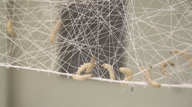
Honestly, it seems like silk pajamas are on a downswing in popularity. Which is a damn shame. But the Mediated Matter Research Group (part of the MIT Media Lab) recently put thousands of silkworms to work on an architectural project that combines the worms’ natural talent with computer modeling.
Silk Pavilion consists of 26 silk polygons which act as the structure of the piece. Made of silk thread laid by a Computer-Numerically Controlled (CNC) machine, the polygons were a template on which to place 6,500 silkworms which produced natural, unprocessed silk patches. The silkworms worked until the whole structure had been covered.
The CNC used an algorithm that had analyzed the patterns in worm-generated patches of silk, and then produced the first level of structure. The silkworms themselves created the second level, working as a sort of natural 3D printer. This gets to the heart of the piece as an interplay between natural and digital construction. The next trend in interior design should definitely be loosing thousands of silk worms on your house and letting them redecorate. [Creative Applications]